Frequently Asked Questions
What is GPR? (fundamentals)
Ground penetrating radar (GPR) is a non-destructive subsurface imaging technology that transmits short pulses of electromagnetic energy into the ground and records the reflected signals to produce a real-time image of what lies beneath the surface. It can detect and map both metallic and non-metallic objects, geological layers, voids, and buried infrastructure without excavation.
GPR works through any penetrable material — soil, concrete, asphalt, ice, or water. It is widely used across utility locating, archaeology, road inspection, environmental investigation, and military applications. Other common names for GPR include impulse radar, geo radar, and ultra-wideband (UWB) radar.
Visit the Technology page to learn more
As a safe and non-disruptive method, GPR is the ideal way to investigate the subsurface for a wide range of applications. Deploying GPR in the field is easy, and sites can be scanned rapidly, which also makes it an economical choice.
Originally pioneered as a non-destructive technique for geophysical investigations, GPR can be used to obtain information about what lies beneath the earth’s surface and to non-destructively detect and map both natural geological features and buried man-made infrastructure.
Visit the Benefits page to learn more
A GPR system works by moving an antenna across the surface of the material being investigated. The antenna continuously transmits ultra-wideband electromagnetic pulses into the ground and records the time and strength of the returned reflections. These reflections occur wherever there is a change in material properties — for example, where a pipe, cable, void, or geological boundary is present.
The time each signal takes to return indicates the depth of the feature. By recording thousands of measurements per second as the antenna is moved, the system builds up a cross-section image called a radargram. Modern systems like those made by ImpulseRadar display this radargram in real time on an Android tablet or ruggedized device.
Visit the Technology page to learn more
Real-time sampling (RTS) is a digital signal acquisition method in which the GPR system captures and processes the full radar waveform in real time, rather than using older stacking or sequential sampling techniques. ImpulseRadar is the only GPR manufacturer offering an entire product line built on real-time sampling technology.
RTS delivers three key advantages over older designs: significantly higher data acquisition speed (enabling surveys at highway speed with the Raptor system), greater bandwidth and resolution for detecting smaller objects and finer detail, and more consistent signal quality regardless of survey speed. This means less time in the field, more reliable data, and better outcomes on complex projects.
Visit the Technology page to learn more
GPR and electromagnetic (EM) locating are complementary technologies used for utility detection, but they work differently and have different strengths. EM locating detects the electromagnetic field around metallic, conductive utilities (pipes and cables) and requires a signal to be applied to the line. GPR transmits radar pulses into the ground and can detect both metallic and non-metallic objects — including plastic pipes, fiber optic cables, and concrete — without needing direct contact with the utility.
GPR is often used alongside EM locating on the same job to maximize detection coverage. Where EM finds known metallic lines, GPR identifies non-conductive pipes and previously unknown buried objects. ImpulseRadar’s PinPointR is designed to allow GPR and EM surveys to be run simultaneously.
GPR can be used for a broad range of applications.
Visit the Applications page to learn more
GPR depth penetration depends primarily on two factors: the antenna frequency used and the electrical properties of the material being investigated. Lower frequencies (70–400 MHz) penetrate deeper — up to 10–15 meters in dry, low-conductivity soils — but provide lower resolution. Higher frequencies (400–800 MHz) offer better resolution for shallow targets but penetrate less, typically 1–3 meters.
ImpulseRadar’s CrossOver system covers 6 frequency options from 70 MHz to 800 MHz, allowing operators to select the right frequency for their specific application and site conditions. Wet, clay-heavy, or saline soils significantly reduce penetration depth for all GPR systems.


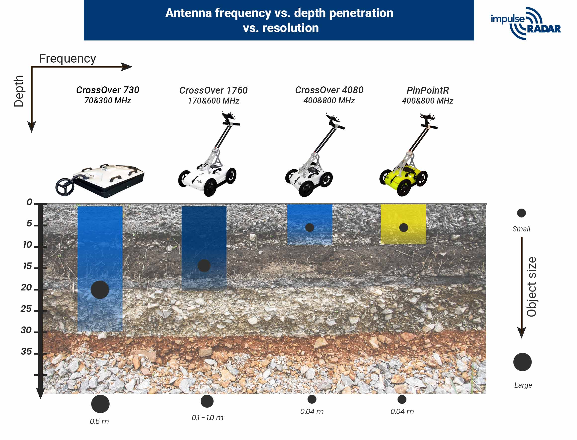
A good advice is to use the lowest frequency possible for resolving what you want to see. A high frequency will cause reflections from smaller targets and this will make the radar image more difficult to interpret. This is often referred to as “clutter”.
Are you interested in budgetary pricing or a formal quotation? Use the contact form on our Contact Us page and one of our sales representatives will be in touch.
GPR doesn’t pose any health threats. The use of GPR and the associated permissible radiated emissions are regulated in all significant markets and ImpulseRadar systems are certified to the latest international standards of CE, FCC and IC.
ImpulseRadar products
ImpulseRadar manufactures a full range of ground penetrating radar systems for professional subsurface investigation, all built on real-time sampling (RTS) technology. The current product line includes:
• PinPointR — a dedicated utility GPR with integrated dual-frequency antenna (400 & 800 MHz), built-in GPS, and wireless Android interface for utility locating
• CrossOver — a versatile multi-frequency GPR series available in three housing options with 6 antenna frequencies from 70 to 800 MHz, for a wide range of applications
• Raptor — a high-speed 3D GPR array for road and infrastructure surveys at highway speeds up to 80 mph
• PLT 600 — a specialized GPR system for ice and snow inspection, including a winter-ready ice edition
ImpulseRadar also develops its own software suite including Condor, Talon-2, ViewPoint, and ViewR for data acquisition, processing, and visualization.
The PinPointR is ImpulseRadar’s dedicated utility locating GPR, designed for professionals who locate, map, and avoid underground utilities before excavation. It was the first real-time digital dual-frequency wireless GPR system on the market, combining 400 MHz and 800 MHz antennas in a single, cable-free unit.
The PinPointR includes built-in DGPS (upgradeable to RTK precision), an Android-driven touchscreen interface, automatic field report generation, and real-time utility marking directly to Google Maps via the ViewPoint app. It meets APWA color-coding standards and is designed for one-person operation. It is NULCA-verified and used by utility locating professionals, municipalities, contractors, and engineering firms.
The Raptor is ImpulseRadar’s high-speed 3D GPR array system, designed for large-scale road, highway, and urban utility mapping where traditional slow-moving GPR surveys would require lane closures and traffic control. It operates at survey speeds in excess of 80 mph (posted speed limits), collecting 3D GPR data at 5 cm point intervals.
The Raptor is used by road authorities, departments of transportation, and utility mapping companies to rapidly survey long road corridors, map buried infrastructure, assess pavement layer thickness, and detect subsurface voids. It attaches to any vehicle via a standard receiver hitch and requires no traffic management during data collection.
The PinPointR and CrossOver serve different primary use cases. The PinPointR is purpose-built for utility locating: it has a fixed dual-frequency antenna (400 & 800 MHz), integrated GPS, and a workflow optimized for field marking, reporting, and APWA-standard utility designation. It is the best choice for professionals who primarily locate and mark utilities for excavation safety.
The CrossOver is a multi-purpose GPR system offering 6 antenna frequencies from 70 to 800 MHz, available in three housing configurations. It is the better choice for applications requiring different depths or resolutions — such as geological surveys, archaeology, road inspection, environmental studies, or research — or for organizations that need one system adaptable to many tasks.
Yes. ImpulseRadar USA offers NULCA-accredited GPR training courses. The training meets NULCA (National Utility Locating Contractors Association) standards, ensuring participants demonstrate the knowledge, skills, and understanding required to apply GPR safely and professionally for utility locating.
The training covers GPR principles, equipment operation, data interpretation, field marking procedures, and quality control. Courses are available at scheduled events and can also be arranged for teams. Contact ImpulseRadar USA for details on upcoming course dates.
GPR applications
Yes. Unlike electromagnetic (EM) locating, GPR can detect non-metallic and non-conductive buried objects including plastic pipes, PVC conduit, fiber optic cables, clay pipes, and concrete. This makes GPR essential for complete utility mapping, since EM locating alone cannot detect these materials.
The ImpulseRadar PinPointR uses dual-frequency antennas (400 & 800 MHz) to maximize detection of both shallow small-diameter connections and deeper mains, regardless of material type.
Yes, GPR is widely used in archaeology for non-invasive subsurface investigation of sites. It can detect buried foundations, walls, graves, artifacts, and stratification layers without excavation, making it ideal for heritage site assessment, pre-excavation planning, and site preservation.
ImpulseRadar’s CrossOver system is commonly used for archaeological GPR surveys due to its multi-frequency capability and the ability to adapt antenna frequency to site-specific soil conditions and target depths.
Neque porro quisquam est, qui dolorem ipsum quia dolor sit amet, consectetur, adipisci velit, sed quia non numquam eius modi tempora incidunt ut labore et dolore magnam aliquam quaerat voluptatem. Ut enim ad minima veniam, quis nostrum exercitationem ullam corporis suscipit.
Yes. GPR is well suited to ice and snow inspection and is used for measuring ice thickness, mapping internal ice layers, detecting voids beneath ice, and assessing snow depth and density. These applications are important for infrastructure safety, polar research, water resource management, and winter road maintenance.
ImpulseRadar offers the PLT 600 Ice Edition, a GPR system with a Wi-Fi-connected antenna optimized for ice and snow conditions, with no cables between the radar, GPS device, and Android tablet.
Buying and using GPR
For professional utility locating, ImpulseRadar recommends the PinPointR. It is the only real-time digital dual-frequency wireless GPR system built specifically for utility location workflows, combining high detection performance with a field-friendly Android interface, integrated GPS, automatic reporting, and real-time Google Maps marking.
For organizations that need to cover large road corridors quickly, the Raptor array is the better choice. For teams requiring one system across multiple application types (utilities, geology, archaeology, road inspection), the CrossOver series offers the most flexibility.
ImpulseRadar develops its own software suite for data acquisition, processing, and visualization. The main applications are: ViewPoint (Android app for real-time field data collection, utility marking, and report generation, compatible with PinPointR and CrossOver); Talon-2 (the control and data acquisition software for Raptor 3D GPR arrays); Condor (desktop processing and interpretation software); and ViewR (data review and reporting).
All ImpulseRadar software is designed to be intuitive and regularly updated. The latest versions of ViewPoint and other apps are available on the ImpulseRadar Resources page.
Yes. ImpulseRadar’s ViewPoint app exports utility marks as KMZ/KML files compatible with Google Earth, ArcGIS, and other GIS platforms. Marks can also be exported directly to CAD. The PinPointR’s ViewPoint app generates automatic PDF field reports with embedded Google Maps and X/Y/Z coordinates of all marked utilities, which can be emailed immediately from the field.
For survey-grade mapping, the PinPointR is upgradeable to integrate with RTK GNSS systems (including Emlid receivers, for which ImpulseRadar USA is an authorized distributor in North America) for centimeter-level precision positioning.
ImpulseRadar offers a 5-year warranty on the PinPointR antenna. All other ImpulseRadar products and parts are covered by a 2-year warranty. Contact ImpulseRadar or your regional distributor for full warranty terms and conditions.
About ImpulseRadar
ImpulseRadar is a Swedish GPR manufacturer headquartered in Malå, Sweden. The company develops and manufactures ground penetrating radar instruments and software, and is the only GPR manufacturer offering an entire product line built on real-time sampling (RTS) technology. ImpulseRadar is part of the Addtech Group, a Nasdaq Stockholm-listed technology group with approximately 3,000 employees across 140 subsidiaries.
ImpulseRadar has a subsidiary in the Americas — ImpulseRadar USA, Inc., based in Ravenel, South Carolina — which handles sales, training, and support across North and South America.
Visit About ImpulseRadar page to learn more
ImpulseRadar’s key differentiators are:
- Data quality
- Antenna performance
- Build reliability.
- ImpulseRadar antennas are engineered to maintain strong signal penetration in low-conductivity soil conditions where competing systems lose depth and resolution — a critical advantage on difficult sites with clay-heavy, mineralized, or variable ground.
- ImpulseRadar systems are also designed to be fast to set up and straightforward to operate. The Android-based interfaces are intuitive enough that teams can get productive results in the field with minimal configuration time — a practical advantage on jobs where speed matters.
- Customers consistently report that ImpulseRadar systems are robust, reliable, and built to a high standard.
- ImpulseRadar takes a customer-focused approach to product development: the team actively listens to users and implements new features and updates based on real-world feedback from the field. This means the product roadmap is shaped by the people who use the equipment every day, rather than by generic market trends.
- On the warranty side, the PinPointR antenna carries a 5-year warranty, while all other products and parts are covered by a 2-year warranty.
ImpulseRadar GPR systems are available directly through ImpulseRadar and through its network of authorized regional distributors and partners. In North and South America, sales and support are handled by ImpulseRadar USA, Inc. (Ravenel, South Carolina). In Sweden and internationally, contact the headquarters in Malå, Sweden.
To request a demonstration, product consultation, or purchase inquiry, contact ImpulseRadar through the contact form at impulseradargpr.com/contact-us/ or call ImpulseRadar +46 953 100 08(Headquarter); USA at +1 843 412 0206.