
CrossPoint – Visualisation Software
ImpulseRadar CrossPoint is a proprietary Windows™ based software program for the visualisation and interpretation of ImpulseRadar ground penetrating radar (GPR) data files. CrossPoint can import and work with data files collected with the ImpulseRadar CrossOver series, PinPointR, and Raptor.
Save time on interpretation with clear and practical tools to maximise your productivity.


Intuitive Workflows for Productivity
The software is intuitive and easy-to-use and provides effective tools for filter assignment, data processing, marking points of interest, visualising profiles and markers in the site view – including online map support, and exporting markers for geo-referencing within suitable CAD/GIS environments.
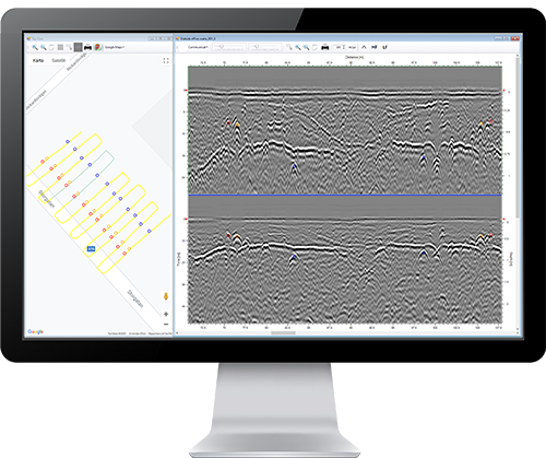
The software excels at simplifying the processing and mark-up of multi-line 2D GPR projects but is equally adept at supporting a single-line projects project. Compatible with the project modes in the ImpulseRadar ViewPoint acquisition App, CrossOver and PinPointR data sets can be processed quickly and efficiently. By viewing up to ten parallel profiles simultaneously, anomalies in the data can be more easily resolved, which makes for increased productivity.
Profiles from Raptor surveys can be also be viewed, either individually, or together with all profiles in a single swath. This allows quick analysis of 2D data before import into the ImpulseRadar Condor 3D processing software.
Colour-coded markers are used to indicate anomalies or points of interest within the data. These markers show up both in the radar profile as well as the site map. Once a project is complete, the markers (including profiles) can be exported for import into third-party drawing packages such as CAD, or into geographical information systems.
Note – CrossPoint is free to download and run in a ‘demo-only’ test mode, which allows you to open and view ImpulseRadar data files with limited functionality. However, CrossPoint requires a license to enable full operation. Please contact your local ImpulseRadar reseller, or use the Contact Us page, to request further details including pricing.
Related products


Contact Us