GPR in the USA
Ground Penetrating Radar (GPR) is a non-destructive technique of near-surface investigations.
Detecting both metal and non-metallic pipes.


2D GPR Techniques for SUE Projects
3D GPR Array Technology
ASCE (American Society of Civil Engineers) regulates investigation and mapping of utilities in the USA.
The latest changes of 38-22 include the following Changes/ Additions:
Topics Relevant to GPR Array (MCGPR) Data Collection and Interpretation:


Marking utility targets in the field with PinPointR
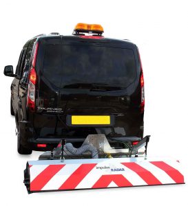
Raptor GPR Array Collection and Processing
ImpulseRadar USA offers NULCA accredited GPR training course
Our GPR training meets NULCA standards to ensure that users demonstrate the appropriate knowledge, skill, and understanding of applying GPR safely and professionally to locate utilities. Contact us today to learn more about the course we offer or to secure your place at an upcoming training event.
EMLID REACH RS2
ImpulseRadar USA, Inc. is an authorized distributor of the EMLID Reach RS2 GPS systems. EMLID is one of the fastest growing GPS manufacturers globally and offers a variety of robust and very easy to use GPS systems for a range of applications. The Reach RS2 is of particular interest to ImpulseRadar customers as it is an affordable addition to the PinPointR GPR system and brings centimeter accuracy to the system.
Reach systems have the most user-friendly user interface for data collection of any system on the market and can be installed on the same Android device customers utilize for the PinPointR. ReachView software is the perfect complement to the ViewPoint PinPointR app. With the new mapping tools built into ViewPoint, customers can move from the already impressive accuracy of the built-in GPS receiver in the PinPointR to survey grade accuracy.
For the Raptor series the Reach RS2 provides streaming NMEA output for high-speed data collection.
The LoRa radio link data transmitter can work to distances up to 4 times longer compared with traditional FSK radios at the same power output. The LoRa radio system is used to connect rover to base when Internet-delivered corrections are not available.
EMLID REACH RX
Pocket-sized and lightweight receiver.
Works with NTRIP corrections
Easy to set up: just add NTRIP
Reach RX uses Bluetooth, allowing you to connect and start surveying in a few seconds. No settings to get wrong.
The weight of Reach RX is just 250 grams. Take it anywhere—it weighs less than a can of soda and fits in any glove compartment or a backpack pocket.
Utility locating color codes USA & Canada

FAQ
As a safe and non-disruptive method, GPR is the ideal way to investigate the subsurface for a wide range of applications. Deploying GPR in the field is easy, and sites can be scanned rapidly, which also makes it an economical choice.
Originally pioneered as a non-destructive technique for geophysical investigations, GPR can be used to obtain information about what lies beneath the earth’s surface and to non-destructively detect and map both natural geological features and buried man-made infrastructure.
Dual Channel GPR

Array GPR (MCGPR)
GPR signal penetration is contingent upon the electrical properties of the ground or penetrable material under investigation, as well as other variables including antenna frequency. Depth range will decrease when there is an increase in electrical conductivity, as typically associated with clay rich soils and higher moisture content.
– Antenna frequency – lower frequencies penetrate deeper (due to longer wavelength) but offer less resolution in shallower layers. Higher frequencies provide higher resolution in shallow layers but don’t penetrate as deep.
– Ground/ soil properties – GPR signal penetration is affected by the dielectric properties of subsurface layers. It’s hard to estimate actual depth penetration for any given site until you are there. GPR works best in high resistive soils absent of conductive layers. Just like a sheet of paper right in front of your eyes can block your view, a thin layer of electrically conductive material underground can block the GPR signal. For example, dry sandy/ gravely soils are relatively “good” for GPR, while clay-based soils are not. Even with dry ground composed of mostly sand/ gravel, a thin clay layer within the near surface can negatively affect GPR signal penetration.
– Water the presence and amount of moisture in sub-surface layers also has an impact on GPR signal performance. Dry soils are more favorable for GPR, while wet soils become more challenging. Saturated clay soil can make GPR almost impossible.


A good advice is to use the lowest frequency possible for resolving what you want to see. A high frequency will cause reflections from smaller targets and this will make the radar image more difficult to interpret. This is often referred to as “clutter”.
Are you interested in budgetary pricing or a formal quotation? Use the contact form on our Contact Us page and one of our sales representatives will be in touch.
